You will admire the unique nature of alternative tourism, especially the highlands of Rize, which is one of the first addresses in our country, to see the tones you have never seen before.
Rize is one of the most important and developed tourism regions of the Black Sea. Especially in spring and summer, Rize has thousands of beautiful beauties visited by tens of thousands of people everywhere in our country. If you have decided to explore these beauties, do not forget to check out our list of places to visit Rize.
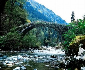
Bridges: There are dozens of bridges built on the ridges in wonderful nature in Rize. Most of these bridges, made of many stones, are at least 100 years old. Kemer Bridge located on Fırtına Stream is the most famous of these bridges. Mikron Bridge, Şenyuva Bridge, Köprüköy Bridge, Caglayan Bridge, South Bridge are among the bridges you can see.
Kalerer: Historical buildings in Rize are also located in the heart of nature. Rize remains among the magnificent valleys are also among these historical buildings. Rize Kalesi, Ciha Kalesi, Zil Kalesi, Bozuk Kalesi and Upper Kale Rize tour dates.
Mosques: Şimşirli Köyü Mosque İslampaşa Mosque, Büyük Gülbahar Sultan Mosque, Küçük Gülbahar Hatun Mosque It is located in the first place among the historical glass that you can visit in Rize.
Plays: The first images that come to mind in the sense of Rize are of course lush with its lush nature and unique beauties. In Rize, highland tourism is also quite developed; there are dozens of highlands here. The world famous Ayder Plateau is one of the first places seen in Rize. In addition to Ayder, Rize ',' Ozit Plateau, Hazindak Plateau, Gito Plateau, Polakcur Plateau, Çeymakçur Plateau, Avusor Plateau, Kavrun Plateau, Samistal Plateau, Kale Plateau, Sal Plateau, Pokut Plateau, Palovit Plateau, Elevit Plateau, from the springs you can visit.
Rize Houses: When you reach the Rize highlands, you will find Rize Houses. Historic Rize Houses, also known as Hemşin Houses, are stone and wooden houses built as a mansion type. The most beautiful examples of Hemşin Houses are located in Ayder Plateau.
Kaçkar Mountain National Park: Another famous natural beauty of Rize is Kaçkar Mountains National Park. Kaçkar Mountains National Park, which hosts plants and animal species that are not found elsewhere in the world, is located within the borders of Ayder Plateau.
Mills: If you want to witness more closely to Rize's history, you can also visit museums in the city. Rize Museum and the Rize Atatürk Museum (Mataracı Mehmet Efendi Evi).
Rize Places of Worship - Historical Places
Gelintulu Waterfall

Gelintulu Waterfall
It flows between the colorful nature of Ayder Plateau, Gelintulu Waterfall. Especially in spring and summer, seyrine is not satisfied.
The Gelintulu Waterfall, which leaves the waters of the Kavrun Stream from the skirts of the Kaçkar Mountains, is one of the most unique formations of nature. While the waterfall is flowing, the waterfall is called Gelintulu Waterfall because it resembles the wall of the bride.
The waterfall is also one of Turkey's longest waterfalls. Gelintülü Waterfall, which has an admirable beauty, is located approximately 90 kilometers away from the city center. Within the boundaries of Ayder Plateau, it is also an easy access to the waterfall.
If you are going to Ayder Plateau or plan to have a pleasant holiday, you should definitely include the Gelintulu Waterfall on your sightseeing list.
Rize Museum

Rize Museum
The Rize Museum offers a wide range of information about the city as well as about its culture and tradition. It is located in the district center.
One of the first places to be seen on Rize sightseeing is the Rize Museum, a building in the city center called "Yellow House". The house where the museum was located served as Ataturk House in 1984. In the following years, he was taken by the Ministry of Culture and served as a museum in 1998 after his restoration work.
More than 70 archaeological artifacts, close to 600 sikkesi, more than 1000 ethnographic artifacts are found in Rize Museum. It is also possible to see manuscripts at the Rize Museum, which has a rich collection.
Anzer Plateau

Anzer Plateau
Located at a distance of 35 kilometers from Rize's Ikizdere district, Anzer Plateau is one of the most important parts of the geography, which is endowed with endemic flower species.
The area of Anzer Plateau is wide and forms the borders of Lower Anzer (Çiçekliköy) and Upper Anzer (Ballıköy). The field where the famous Anzer honey is produced is also at the same time. Due to this reason, local and foreign tourists are interested ...
Anzer Plateau was declared as a tourism region in 1991 due to its nature and hosting of the famous Anzer honey.
Anzer Plateau, which is rich in fauna and flora, is suitable for paragliding, peak climbing and trekking. In other words, Anzer Plateau, which appeals not only to those who want to spend time in nature but also to those who are interested in sports full of adrenalin, is a point that should definitely be included in Rize holidays.
Büyük Gülbahar Sultan Mosque

Büyük Gülbahar Sultan Mosque
The Great Gülbahar Sultan Mosque, located in the center of Rize and within the boundaries of the same name, is very new and robust because it has been constantly repaired, even if it is one of the old worship places of the city. The reason for this is that the glass has been demolished and rebuilt many times.
It is unknown what year the Great Gülbahar Sultan Mosque was built. The minaret is removed from the last congregation site and the minaret is located on the west side. All of the glass is rectangular. The Great Gülbahar Sultan Mosque, which lost its original architecture, is now open for worship.
Mikron Bridge

Mikron Bridge
The Mikron Bridge between the historic bridges in the Fırtına Valley is very close to the Underwater Village of Çamlıhemşin.
The bridge, dated to the 19th century, was built during the Ottoman period and has almost the same architectural characteristics as the other bridges in the region. The micron bridge, which is made of rubble and cut stone during its construction, is 30 meters long and 12 meters above the stream level.
The bridge has been able to come up to date with its solidity and the repair done by the Highways in 1999 is the last day.
Senyuva Bridge

Senyuva Bridge
Şenyuva Bridge, which is one of the historical monuments of Rize-Çamlıhemşin and continues to be used, is the oldest bridge of the region.
The former name is the Chinese-domed bridge and it has a single arched structure. It lies on the Crater Creek and extends in the east-west direction. According to the people of the region, the book of the bridge disappeared in 1946. The fact that the date written in the book is 1699 is also spoken by local people. The total length of the bridge, which is 15-20 meters above the stream level, is 40 meters.
This old historical structure, hidden among the green nature of Çamlıhemşin, can be one of the most beautiful spots of your Black Sea turd.
Şimşirli Village Mosque

Şimşirli Village Mosque
Şimşirli Village Mosque located in Rize-İkizdere is one of the historical worship places of the region.
The first construction works of Şimşirli Village Mosque started in 1853. It was built in 1857 by Ahmet Usta. During the construction of the glass, the wooden masonry technique was used. The architecture is square plan and is located on a sloping ground. The presence of a rugged spot ensures the use of high stone wall molds.
There is also a madrasah near the Şimşirli Village Mosque. The madrasa was built in the same year as the glass.
Rize Castle
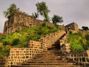
Rize Castle
Rize Castle is located in the city center, so it has an easy access route. The castle, the inner castle and the lower castle split into two, but the castle has almost disappeared today.
The interior castle was used by the Genoese for a period. A time was devastated and later renewed in the Byzantine Emperor Justinian period. It is one of the places visited by tourists coming to this beautiful city of Karadeniz today. The castle attracts a great deal of attention due to its splendid architecture and being located in the city center of Rize.
İslampaşa Mosque
We will talk about the Islampaşa Mosque, one of the historical values of Rize, between the air of the Black Sea, the water and the cities reflecting its nature.
Islampaşa Mosque is located in the center of the province and has an easy access route. He lives in Islampaşa Quarter where he carries the same name.
The mosque, built in 1571, is also known as the Kurşunlu Mosque. Banis is Alexander Cafer Pasha.
The Mosque of İslampaşa is made of rubble stone, the architecture is rectangular and it is one of the most easily accessible historical and religious sites of Rize.
Ciha Castle

Ciha Castle
Rize is one of our cities that reflects its history and nature at every corner. This unique city, where you will feel yourself in a world where only green dominates, there are as many unknown spots as are known.
We will talk about Ciha Castle, which is waiting for you to be discovered by tourists on this page. It is known that it was built by the Genoese on the borders of the castle and the sultanate. The periphery of Ciha Fortress is surrounded by trees. Work is being done to gain the tourist who does not have much information about it. You may be one of the earliest discoverers to include Ciha Castle in the Rize tour.
Çağrankaya Plateau

Ciha Castle
Rize is one of our cities that reflects its history and nature at every corner. This unique city, where you will feel yourself in a world where only green dominates, there are as many unknown spots as are known.
We will talk about Ciha Castle, which is waiting for you to be discovered by tourists on this page. It is known that it was built by the Genoese on the borders of the castle and the sultanate. The periphery of Ciha Fortress is surrounded by trees. Work is being done to gain the tourist who does not have much information about it. You may be one of the earliest discoverers to include Ciha Castle in the Rize tour.
Çağrankaya Plateau...

Çağrankaya Plateau
One of the heavenly cities of the Black Sea, Rize is a place where many local and foreign tourists visit during the year.
Çağrankaya Plateau located in Rize-İkizdere attracts attention with its natural beauty. The settlement of Çağrankaya Plateau is summer. It is not used because it is snowing in winter. Yaylaya, Küçükçayır, Çayeli, Güneysu and İkizdere. Especially the Çağrankaya Plateau offers a spectacular view when the fog collapses. If you are planning to explore Rize, you should definitely visit Cagrankaya Plateau. Çağrankaya Plateau, inviting you from afar, will appeal to your eyes as well as your soul. You can also visit Hazindak Plateau, Gito Plateau and Storm River.
Ovit Plateau...

Hazindak Plateau
There are only 20-30 houses in the Hazindak Plateau's Rize-Çamlıhemşin and you will not have difficulty in transportation.
This area you will go through Ayder Plateau, you can reach the Pokut Plateau from Şenyuva Village and walk there by foot from Amlekit which will take 1-2 hours.
This mountain has taken its name from Mount Hazin. You will take the most beautiful pictures, new beauties are just one of the places you will discover. Hazindak Plateau, which has not lost its naturalness, is among the places preferred by those who love to explore and those who want to disappear in nature ... It will provide you with moments that you can not forget to visit Hazindak Plateau during your Rize tour. Of course you can also include the fascinating views of Çağrankaya Plateau, Gito Plateau and Ovit Plateau.
Palovit Waterfall

Palovit Waterfall
Palovit Waterfall is one of the natural beauties Turkey has spread to every city. Located at Rize-Çamlıhemşin, Palovit Waterfall is the highest waterfall waterfall in the region.
Among the green colors are laid out like a white and thin cover on their own bed. Access to Palovit Waterfall, which is an important part of the unique nature of the Black Sea, is quite easy. After crossing the Bell Castle from the direction of the castle, you can reach it by entering the road section. You should choose to walk by road; because the road is not suitable for cars. You can walk to the waterfalls and you can also enjoy the views of this road. Do not forget to cool down in the Palovit Waterfall. Palovit Plateau, Gito Plateau, and Hazindak Plateau can all be included in the list.
Gito Plateau

Gito Plateau
Rize offers all the greenery, springs and plenty of oxygen every year. Rize, one of the most indispensable cities of the Black Sea, will be a very high plateau for you to visit. Polakcur Plateau, Çeymakçur Plateau, Ovit Plateau, Çağrankaya Plateau, Hazindak Plateau, Avusor Plateau ...
But most of the springs are unknown. Just like Gito Plateau ... Gito Plateau is one of the newest spots in tourism. With this plateau, which few people know, you will present the most crucial scenes of every step. Clouds are like a house; the fog over there is so dense that you think clouds have landed on the surface of the sky. Gito Plateau, a white cover under your feet, shows green and blue in this view.
Rize-Çamlıhemşin You may be one of the first discoverers of Gito Plateau on your trip. Seeing the dominance of a magnificent nature will take you to a fantastic world.
Storm Creek

Storm Creek
It is one of the places preferred by adrenaline and nature lovers Fırtına Deresi. The Fırtına Stream, which is poured with great enthusiasm to the Black Sea after approximately 2 kilometers from Ardeşen, is 57 kilometers long.
It is a region of interest of domestic and foreign tourists, especially those who are interested in water sports, and the rafting has the most suitable tracks. Another beauty that is suitable for water sports throughout the year is the Storm River. Only on very rainy days should not be preferred. In the meantime, you can start the park about a kilometer after Çamlıhemşin and you need to finish the course before it falls to the Black Sea. You will do in the green nature of Rize and the immaculate air of endlessness; Zil Castle, Polakcur Plateau, Çeymakçur Plateau will be waiting for you discoveries.
Hemşin Houses

Hemşin Houses
Generally, houses made from mansion type are made of stone material and 3 storeys and the upper part is made of wood. In some places stone treatments have been used on the lower floors, and some of the houses on the upper floors were made by filling stone between the woods with the stuffed stone technique.
Some houses are made of barn stones and the upper floors are made by applying wooden material and throat passing technique. In the kitchen area of the mansions there are chimney trunks that can be burned with chopped stones in the kitchens of the houses, chimney tricks that allow the smoke to be thrown out, the yard where the house is located, the yard where the food is stored, the hatchery called the marathon where the house food needs are stored, the head room arranged to welcome guests, and the fireplace bath and toilet.
It is seen that in the systems applied in the wooden construction technique, without the use of any nails except doors and hinges, it is observed that the finest techniques of carving art by wooden house masters, meticulously applied to the doors, windows and corner connections.
The masters who brought the hempin houses to the fountain carried all the responsibility from site selection to material selection until the house was finished and delivered. These houses, which must be protected, have very important cultural values today and in the future.
Kemer Bridge
During the storm lesson, there are 10 Kemer bridges of various sizes from Köprüköy and they have survived to the stormy area where the construction dates have not been determined but the area where they reflect the history of 150 years. These bridges made with chipped stone technique have a separate place in the stone technique of architectural direction.
Senyuva Bridge: Cinciva Bridge, formerly known as the widespread stone bridges of the region. The storm stream was crossed by a single arch. The elders of the village record that a book of H.1111 / M.1699 disappeared in 1946. If this is true, the structure is one of the oldest bridges in the region.
Other works in Çamlıhemş are; Şenköy Mosque 1900), Lower Camlica Village Mosque and Köprüköy Bridge (19th century).
Bell Castle
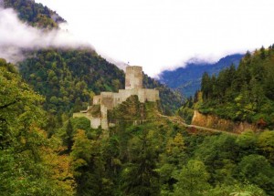
Zil Kalesi
Rize ili Çamlıhemşin ilçe merkezinin 15 km güneyinde, Fırtına Deresi Vadisi’ne hâkim noktada, deniz seviyesinden 750 m yükseklikte, kıyıdan da 40 km içeridedir Dere yatağına hâkim bir kayanın tepesinde bulunan bu kale çevreyi kontrol amacıyla yaptırılmıştır Kalenin kimler tarafından yaptırıldığı bilinmemektedir.
Bölgenin tarihini araştıran Prof A. Bryer kale ile ilgili hiçbir bilgi edinememiş ve dağlar arasındaki geçitlere egemen olan bir derebeyi tarafından yaptırılmış olabileceği görüşündedir Prof Dr. Semavi Eyice’ye göre, yöredeki derebeyi hakimiyeti Osmanlı İmparatorluğu zamanında da sürdürülmüş, asi Tuzcuoğullarının, Trabzon Valisi Hazinedaroğulu Süleyman Ağa ve devlet kuvvetleri ile çarpışmasına kadar, 1840’lı yıllara kadar kullanıldığını ileri sürmüştür
Kale düzensiz bir kaya kütlesinin en yüksek kesiminde ve düzgün bir plana sahip olmayacak şekilde yerel moloz taştan yapılmıştır Kalede tarihlemeye yardımcı olacak herhangi bir bezemeye de rastlanmamıştır Kalenin kuzey yönündeki girişine batı yamacındaki bir yol ile ulaşılmaktadır Kale üzeri beşik tonozlu bir dehlizi olan kapının iç tarafında, tepenin kuzey kısmında kademeli teraslar halinde yapılmıştır Bu teraslar fazla yüksekliği olmayan duvarlarla birbirlerinden ayrılmıştır Tepenin güney ucunda birbirine bitişik iki mekân asıl kale bloğunu oluşturmaktadır Düzensiz planı olan bu bölümlerin kale muhafızlarının barınakları olduğu sanılmaktadır.
Duvarlardaki kiriş izlerinden bu mekânların ahşap döşemeli katları olduğu da anlaşılmaktadır Bu mekânın yanında muntazam dikdörtgen planlı, batı ve doğu yönüne uzanan daha küçük bir mekân vardır Bu mekânın kaleye ait bir şapel olduğu düşünülmüş ise de bunu doğrulayacak bir kanıta rastlanmamıştır Ayrıca bir şapelde bulunması gereken apsis ise burada yoktur Yalnızca kapı girişinin karşısında, batıda içerisi nişli bir girintili hücre bulunmaktadır
Kalenin güney ucu duvarla çevrili bir iç kale görünümündedir Bunun batısında dışarıya doğru taşan dikdörtgen burcun başkule olduğu sanılmaktadır Bu kulenin de düzgün bir planı yoktur Ancak bütün kaleye ve çevreye hâkim bir durumdadır Duvarları 1-5-2 m kalınlığındaki başkulenin zemin katından başka, ahşap döşemeli dört katı daha bulunmaktadır Kalenin aydınlatılmazı mazgal delikleri ile yapılmıştır Ayrıca kulenin üzeri teras şeklinde örtülmüştür
İç kaleden başka dış surlar ve orta surlar kaleyi çevrelemektedir Kale duvarları içerisinde dikine uzanan boru yuvalarının da günümüze gelemeyen sarnıçlara ait oldukları sanılmaktadır.
Palakçur Yaylası

Polakcur Plateau
The Palakçur plateau, which forms the northeastern corner of the study area, is formed at a valley slope at an altitude of 2100 m and consists of three districts. Ardeşen-Beyazkaya, Hala and Civik are used by the villagers. It is 5.5 km away from Ayder and 25.5 km away from the town. It is outside the national park boundary. The population is up to 85 people since late July. The plateaus are starting as of May 30 and the plateau is completely empty during the third week of October. There are 23 rugged, 14 rundown (quarry) houses all of which are wooden but the lower parts are stone.
The non-electric arcade road reached 15 years ago. There is no water in the houses. Picnic tubes and wood are burned in the houses but also used as tezek.
Çeymakçur Plateau

Çeymakçur Plateau
Çamlıhemşin'den Çeymakçur Yaylasına Ayder road is on the way. At the end of the plaza where the traditional bull wrestling called Galerin Düzü, which is just at the end of Ayder Plateau, is made, road 2 is reserved.
When you continue on your left arm from these caves, you reach to Yaylaya. Hüla Yayla is mostly located in Hala Village. Palakçur Plateau is located right next to Çemakçurun. Hemen has the same features.
Avusor Plateau

Avusor Plateau
It is a spring used by the Lazlar region. When going from Ayder to Kavrun, when you turn left to the first left, you are entered to Avusor spring road. The lower part of the Avusor plateau is usually made up of stone houses with wooden houses. Approximately 50 houses are available.
Upstairs, on the other hand, is often shortened to a human neck due to the danger of an avalanche. Especially these houses are covered with décor against the cold, around 50. The Avusor Plateau is the sub-settlement of Kemerli Kaçkar Mountain and is also famous for its name Lake Avusor.
Kavrun Plateau

Kavrun Plateau
The cave is the largest plateau of Rize at an altitude of 2240 m. It is located at the foot of the Kaçkar Mountain and is the closest plateau of the car road.
Rize is one of the three tourism centers in our province. Population is variable in the summer season with 240 houses. It varies between 2500-5000 people in August
Our festivals are held in the beginning of August and ending in the first week of September. Our local festival is called "VARTEVOR". Upper Kavrun Plateau which welcomes many local and foreign tourists at the time of Valentevor is the closest passage way to other spring resorts.
The Kavrun Plateau is said to be a valley covered with glaciers five thousand years ago. The large and small glaciers on the skirts of Kaçkar Mountain have reached Ayder Plateau.
Samistal Plateau

Samistal Plateau
Altitude 2450 m
Transportation: You can reach here via both Ayder and Palovit plateau.
It is recommended that you use the Ayder route if you will drive by car. You will arrive sooner. On the second arrival route, it is possible to get on foot for about 2 hours after you go by car until Palovit.Araba and pedestrian.Airba and Ayder'dan.Yaya Palovit over
Features
One of the greatest features of the Samistal plateau is that the houses are very old and the stones used in the construction of the houses are in the shape of rafts and large masses. No accommodation facilities and restaurants. There is a grocery store and coffee shop.
Castle Plateau

Castle Plateau
Rize province is the last village of Çamlıhemşin, which is 40 km away from the accident and has an altitude of 2800 s. The castle village, located at the point of storm, It is a historic village built on the outskirts of Tatos mountain, forming part of Kacharkar. Erzurum İspir and Artvin Yusufeli had the property of being one of the places where cargo passengers in the past had passed through, as a gateway to the passage.
The name of Kale-i bala was changed to Hisarcık in the Republican years and after this name was mentioned for many years, it was renamed Kale village again and got a name of küya this day. Village settlement is scattered; a few hamlets and neighborhoods. It is used as a barracks and a Kala hamlet; It is used as a boulevard, flower, plateau, middle ridge and head meadow plateau. In these sections used as plateaus; Especially, the middle ridge and the head meadow are the highland houses of the people coming from the neighboring villages. Since the village has intercultural interactions due to this springland characteristic, the weight of the cul-de-sac culture is also seen in the village. In the historical researches, it was determined that the village of Kale did not carry a Hamshen culture and language.
When we examine the structural characteristics of houses in the village; We see that there are roofs of earth covering the black stone walls. The houses consist of a section where the tandır and the castle are located and the second section called Maran. Marine; bed and cellar room, as well as vartivordan and then the area where the grasses were placed.
Besides these black stone and earthy houses; it is also possible to find the houses of the 'keran' lined up. Keran: He called for decent trees of 10-15 meters in length and of considerable thickness. These buildings, which are now museums, left their place in the walls where piri ket stones were walls and roofs were covered with hair. For the sake of speculation, the astonishing door and window stones in the buildings and the huge stones can be brought to this condition under primitive conditions. For that reason, the photographs of these old houses are tabled for almost every tourist.
It is possible to see the soil covered with "warp" beside the dam. Harthouming: It was a fine corrugated board made of a skillfully splitting of specially selected pine logs.
Priority was farming and livestock farming. Wheat farming, wheat barley and wheat were harvested, but these crops were not properly grown or seedless, even if they were later climatic changes. In livestock farming, 10-15 large animals in every house and small animals in hundreds of small animals were nourished and fed. These days, only the hobbies made by the highlands are very talented in terms of ekenomic returns.
Despite the fact that no one can survive the winters today in the village, which is located in the foothills of the mountain, The winters are a cheerful village. Due to their geographical structure and economic structure, the peasants have been busy migrants because they have found a way to survive better and have found a way to survive. By taking land on the beach in the first place; They started to gather in different villages and neighborhoods in the market. migrating from here to big cities; They have started to work in various jobs and professions, or have established their own businesses.
In our villages with large cities, Due to the availability of economic and social conditions, there has been a large increase in literacy rates. Literary authors who have been shown with their fingers have now become people who are known by their proliferating professions.
In the meantime, to put it in detail: Those who migrated from the castle village to the pazara; They are in the market Abdoğlu (write their new name), Hüdisa, Kuvakçe, Duduvat.
In the light of this general information; When we go into more detail and examine the cultural structure of the village, we see a picture of our antagonism. Those who live in the village; They were expected in the form of a few dynasties. According to their numerical crowds, Islam (separated by a few divisions), Kadiogullari (divided by a few divisions), Saints (egs) Köseler, Tonalis, etc .. As they grew in water, they began to take shape as a group of different dynasties. For example: Islam, Alikalar, Ayazlar v.s. This brought about the disintegration of family structures. At the same time, Kale village, which has a closed structure in the past, is the result of these initiations and interactions; intensive culture transfer from the villagers living. Kinship relationships have been developed with families of various cultures. (Kaleli girls first married kalalı men, Kaleli men married kalalı girls and yada cousins)
There are quite a few things to write about the physical structure of the village and its promenade locations. Firstly; Let's talk about Kale-i Baladan which gives the name of the keeper. The village was established at a point where the feud was dominant. The castle, which is claimed to be a noble watchtower, is in ruins these days and the thickness of its walls varies between 0.5 and 1.5 mt re. The height of the walls is different because it is built on a rugged land.
The mosque, which was supposed to be old with Kaley but restored several times, is also an old structure. There are graves claimed to be martyrdom near the castle. However, the graves have been excavated on the possibility of burial. After the historical documentation, the promenade locations of the Kale village are also quite extensive. At the top of the mountains there are small crater lakes. If we count it as a name; It is sandy, starred, chorus and three lakes. It is a place where the people who come to the castle want to see also the photographing enthusiasts because the whole village and the neighboring villagers can be seen from the ridge of the village, which is located at the top of the flowering highlands.
Just like the Kaleliler, which catches the "Bitter Water" sun with natural mineral water, is the first picnic area to come to mind; It is also a place where people who have eczema and disease are called to healing and washed. However, a facility for washing is not yet built and only suitable places can be washed.
It is a water with a lax water feature. This water, which is quite cold, flows even in winter. It is an interesting feature that this water can flow in the season when the buildings are frozen. We will write other cultural features, traditions and customs of the castle village in another section.
Sal Plateau

Sal Plateau
If you follow the back of the pokut plateau, the plateau is reached. Both bowls are close together at a 15-minute walk. It seems that the Pilunçut Kahvesi seems to be waiting for the mules that will never come. The flank has a flat surrounded by houses. Most likely, this flat gave its name to the plateau.
Around this flat there are small, traditional houses of Hamsin suitable for architecture. All of the houses in Sal are wooden, while the ones built in recent years are too wooden in terms of architecture. Sal is also famous for its thirst like Pokut Plateau. It is disadvantageous that there is no river or creek beside it because it is built on the back.
The source waters are very inferior to the plateau, so it is not very useful for springing.
When you reach the area immediately above the houses, you can see "the highest" from Altıparmaklar to Kemerli and Büyük Kaçkar. It is also possible to observe the Caucasus Mountains and the Black Sea when the weather is clear. The most important feature that differentiates the ravine from other springs is that it is used by only one village.
The plateau used by Chinchiva village of Çamlıhemşin starts to fill especially from the beginning of July. Some springboards remain on the plateau until October. An advantage for Sal residents is that it is a 45-minute drive away from the villagers
Palovit Plateau

Palovit Plateau
The Palovit Plateau is a spring reaching down from Trovit Plateau. Meleskur Plateau is located just opposite the Palovit Plateau located 4 hours' drive away from Çamlıhemşin.
These two highlands are separated from each other by the descent from the Apevanak Plateau. The Palovit Plateau is on the side of the path leading to Samistal. It is directly opposite the arc. Palovit Plateau is a springs used by the Hemşin district, which is called Hamshen although it is on the border of Çamlıhemşin.
The Palovit and Meleskur platypuses are important springs in today's history, as they are the "point of highland" preservation of the livestock activities and as a transit point. The architectural structure of Palavit and Meleskur Plateau are examples of traditional stone work, but it is slowly losing its original character. The influence of the car drive on these two arcades was great.
The Palovit plateau is used by Çilingir, Arsavos, Sefalı villagers of Çayeli and Çaneva and Ortaköy villages of Hemşin
Amlakit Plateau

Amlakit Plateau
As Kotençur goes to Amlakit highland, the traditional horon place of the yaylacılar passes through Pasogut Düzü. When the path is followed, the Amlakit highland, where the Palovit level is divided into two, is reached at the end of the forest.
Amlakit is celebrated with enthusiasm for Vartavor celebration. Amlakit is at the transition point to Mejo, which is known as the honey pots of Palovit Valley. With this transition, the most dangerous areas of Palovit are entered.
Plant cover can interfere with people's transportation from time to time. Although the road to Amlakit highland five years ago made it possible for more people to come to the plateau, it took a course that destroyed the ecological balance of this valley.
The Amlakit plateau is still used by Lower Vice, Hala, Habak villagers.
Elevit Plateau

Elevit Plateau
You can see the typical highland houses at elevation 1,800 meters. Most of the people who have migrated to the big city come to the region in the summer season for two to three months. A three hour walk can be made from the Elevit, where lodging is available, to the highland park. The Elevit plateau, which entered the process of building a large building after the 80s, is actually composed of two parts. The area known as Tafteni is the second area outside the main building (where the plate houses are located) where the largest sections of the buildings are large. is also the stop.
Although Elevit is actually known as a plateau, it is a village because it is also a mukhtar. The new name is Yaylaköy. But this new name is rarely used. It is said that there is also a market named Yok Yok which is used by Kubuve, Mollaveyis, Omokta and Golunavb villagers of the Elevit Plateau of Çamlıhemşin and has modern and modern houses as well as those who meet "Altitude: 1800, Population: Uncertain" a plateau with a dancing flare. Entertainment at the Elevit is held every year after the 15th of August. In the past, we have been in the form of grass in the past (Vartivor). But in time, this tradition left its place to more fun because of the migration of the city. Elevat is the most horon comes to mind. In the day, it is the horon tour, picnics and soccer competitions because the day is usually horon in the evening hours. There is no time restriction of the horon. It is the horon where the turkler He wants to come to the elevator. Here are the Elevit Funs ...
When we talk about Elevit, it would be wrong to cross the horon with two words. It is known that 90% of the people who come here to play horon just because of yesterday came back to the village or to the cities after they came together and played horon in the evening. horon festivals also require professionalism. Everyone here can not play horon, it attracts attention. We need to know some things. We do not have to be mistaken if we play the place after the rehearsal. It is unexpected moment in the future. If you are not a crusher, a turkey is not much important to whom you are telling. There is a brother or a bachelor here, brotherly and friendly, the folk song is played and arm coke horons are played. Horons are thus more meaningful.
Kaçkar Mountains National Park
Kaçkar Mountains National Park
Rize Kaçkar Mountains National Park is a field of 51,500 hectares which is declared as a National Park in 1994, which is under the protection of Ayder Plateau in the border of Çamlıhemşin district of Rize.
The National Park is important with plant and animal species that are not anywhere else in the world.
In the Kaçkar Mountains National Park you can see lakes, meadows, forests, glacier valleys, wildlife foxes, bears, pigs, martens, jackals, mountain rooster, deer and wild goats.
Ayder Plateau Hot Springs

Ayder Plateau Hot Springs
The thermal spring, which was known and used by the people of the region for years in Ayder Plateau, has been transformed into a health center in 2005.
In Ayder Plateau, which is a wonderful natural place, we visit Ayder Plateau to enjoy the spa enjoyment and to find health all over the country.
I would strongly recommend Ayder Plateau and Ayder Plateau Springs to find healing in the green and to breathe clean air.